
In her recollections, “A Goodly Heritage,” Dorothy Payne Fountain wrote: “I am glad that the Town Fathers of Shelter Island have kept a public access to Hay Beach so that we and our children’s children can continue to lie on the sand and listen to the sea gulls, and sit on the rocks and wait for the tide ... and remember!”
IN THE BEGINNING
During the Revolution, the British thought this sandy spit of beach at the north end of our Island was an ideal place to ease in a barge and load it up with hay for their horses, stabled in Newport, RI. Local farmers collected the hay and the area became known locally as Hay Beach. The name stuck, and about 190 years later, Hay Beach became the largest subdivision ever to be filed with the Town Planning Board.
The original developers of Hay Beach were all direct descendants of Nathaniel Sylvester (1610‐1680), the first lord of Sylvester Manor, and also direct descendants of the 11th lord of the manor, Eben Norton Horsford (1818‐1893). Horsford, Harvard’s first Chemistry professor and a successful capitalist, bought the northeast of the Island for the Manor. His will left the remaining lands in a trust that permitted and seemed to encourage the sales of the property. But the development did not take shape until the 1950’s.

When presented, the development plan for Hay Beach seemed so large to the Town Planning Board that the Board requested that, under the aegis of the development plan, separate subdivisions should be submitted for separate Town Board approval. Many long‐time residents still speak of Section 10, (Point Lane) and Section 6, (the separate area Hay Beach south of Cobbets Lane.)
Hay Beach’s development moved slowly. Sylvester Prime was a farmer of many acres north and south of Cobbetts Lane. In 1962 they offered the development for sale on a wholesale basis, and in 1966, a group of investors, led by experienced developers Mel Weill and Henry Kessler, took over.
Before the subdivisions, Hay Beach had very few residents. It was thought of as a little‐used portion of Dering Farm, which was also part of the Manor.
During the Revolutionary War, the wild hay that grew at Hay Beach Point attracted British ships, which carried troops and horses for the invasion of Long Island and New York. Becalmed, they harvested the wild hay and called on the Islanders for more hay and other supplies to be deposited on the Point for pick‐up. The event is remembered in the name of the point and of our community.
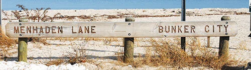
During the 19th century, Hay Beach Point also had a processing plant for the catch and processing of menhaden—bunkerfish—into oil and fertilizer. It was a smelly, but profitable business until it interfered with the resort season, and while it prospered, its casual workers had huts along Coecles Harbor, memorialized in a sign at Menhaden Beach that points to Bunker City.
Since the early 1890’s, a large and portion of Hay Beach has been devoted to a golf course, a forerunner of Gardiner’s Bay Country Club.

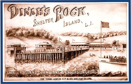
Eben Norton Horsford tried to create a resort for day-trippers, but soon gave it up. The resort, known as “Dinah’s Rock” (believed to be named after the freed slave Diana Williams who lived in the area during the early 1800s), had a carousel and picnic facilities and was accessed by steamships from Connecticut. The resort left its mark in the name of Carousel Lane and, underwater, in the still-visible stone pilings for its pier.
SUBDIVISIONS
The first subdivision was along Dinah Rock Road. The next were along Gardiner’s Bay Drive and Country Club, Hay Beach Road, Crescent Way and Great Circle Drive and Point Lane.

The growth of hay beach through the years
1950 - 2019

Thanks to authors and Hay Beach residents Kathleen Gooding, PhD and Linda Holmes for the above information.
For more in-depth history, including many historical photos, “Then and Now: the Story of Hay Beach” is available at the Shelter Island Historical Society for $20 per copy.

REGISTER YOUR HOME:
Every house has a story to tell.
Tell us the story of your home—even if it’s new. Future generations will thank you!
Back in the early 1900s, Ralph Duval photographed almost all of the homes on Shelter Island. Some people have given information about their homes to be kept in Shelter Island Historical Society’s archives. When researchers gather information about families, homes, or changes in our community they depend on the SIHS archives. Future generations and homeowners would love to know about your home. Don’t forget to share information about previous owners, renovations, interesting guests, or stories that help make your house be a home. Visit the Historical Society’s website at: ShelterIslandHistorical.org/houseregistryproject.html to complete the form.
From the SIHS website: The purpose of the Registry Program is to collect information on Shelter Island homes/buildings. Whether your house/building has been standing since the late 19th century or your home is a new construction, our goal is to register every home/building on Shelter Island to benefit future researchers and historians. The Registry can be used to trace ancestral footsteps, discover the names and anecdotes of previous homeowners, and outline architectural history.